Comments by the ‘Ambrook Valley and Slopes Residents Group’ on the proposed Wind Farm Development at Wind Map Site 23 (South of Broadhempston) as contained in the Draft Teignbridge Local Plan (2020 – 2040) Part 3 (Renewable Energy, Gypsy and Travellers and Residential Sites Options)
Draft 4
These comments are assembled by and on behalf of the undersignatories:
S.A Hickey
A J Hickey
R Humphrys
P Humphrys
V Butler – Cole
B Butler – Cole
D Cunliffe
V Cunliffe
T Baker
R Baker
C Smythyman
M Nathan
J Marles
J Marles
G Montgomery
J Montgomery
S Herbert
J Herbert
S Heaver
S Preston – Ellis
H Peplow
C Peplow
J Holl
A Holl
C Catlow
W Lasdun
J Cubbon
D Jenkinson
Angela Dodd – Crompton
We are grateful to Mrs Emma Heaver BA (Hons). MA Architecture Conservation, RIBA, for her advice and guidance with the planning issues of relevance to this commentary.
Introduction
As part of the above section of the Draft Teignbridge Local Plan (2020 – 2040) Part 3 (Renewable Energy, Gypsy and Travellers and Residential Site Options) a proposal has been brought forward to consider inclusion in the Local Plan of acceptance in principle of a planned development at the site known as WS23 ‘South of Broadhempston’ (as defined by the Exeter University study Wind Resource for Teignbridge map). The proposed site 23 is located on elevated ground above the village of Broadhempston at an elevation of 100m pprox.. above sea level. The site envelops an established woodland which is a popular local landmark. There are many residential properties which will be directly affected by the construction and operation of a wind turbines on the site. The consultation states that the development is likely to consist of a Wind Turbine Farm using 3 or more 110 – 120 metre, 2 megawatt Turbines spaced about 500 metres apart. Such turbines would be approximately 30 metres higher than Big Ben. They would require extensive reinforced concrete foundations (up to 20 feet deep and the same width as the radius of the turbine blades)and support buildings.with grid connections, security fences and lights . The turbines would be highly visible; bright white (possibly with one red blade) with red lights at night. Extensive work would be required to build approach roads to allow access to the site to deliver turbine components (such as tower sections, turbine blades, gearboxes) and materials for construction and regular blade replacements 9required on average every 5 years)
Site 23 lies across DCA 20 and DCA 40 of the ‘Assessment of Landscape Sensitivity to Onshore Wind Energy Developments in Teignbridge District’ which states that all areas of Teignbridge District Council would be moderate to highly sensitive to large wind turbines (76-110m) and moderately sensitive to turbines 51m – 75m tall.
‘The assessment also notes that the LCT would be highly sensitive to turbine clusters larger than 5 turbines. This indicates that the landscape will be particularly sensitive to turbines greater than 51m and unlikely to be able to accommodate turbines over 76m to tip, or any developments comprising more than 5 turbines (sic) without introducing a change to landscape character’ (source https://teignbridge.gov.uk/media/6357/wind-web.pdf)
Turbines of any size in this location would cause considerable Noise Pollution to residential properties nearby. They would also have a negative and detrimental impact on the character of the rural landscape, as well as a negative impact significantly affecting the setting of nearby heritage assets.
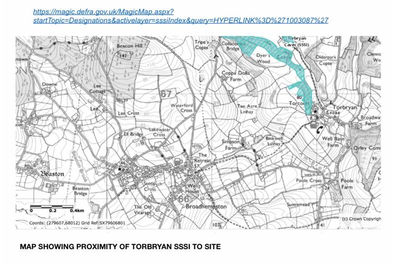
Any proposal would adversely affect the integrity of the South Hams Special Area of Conservation and the SSSI of Torbryan Caves. There are intervisibility issues concerning Dartmoor National Park ( especially the distinctive skyline features of Haytor, Saddle Tor and Rippon Tor) and The Iron Age Hill Setlement at Denbury Down). It would impact the range of biodiversity and geodiversity of the surrounding countryside, as well as on the medieval field landscape and use valuable agricultural land.
The infrastructure and narrow lanes are incapable of supporting the necessary access which would necessitate the construction of new access roads, with additional impact on the landscape character and ecology of the area.
Details of the site as cited in the draft plan:
Wind Site 23 – South of Broadhempston
Ref: WS23
Address: South of Broadhempston
Parish: Broadhempston and Denbury & Torbryan
Size: 26ha
Description
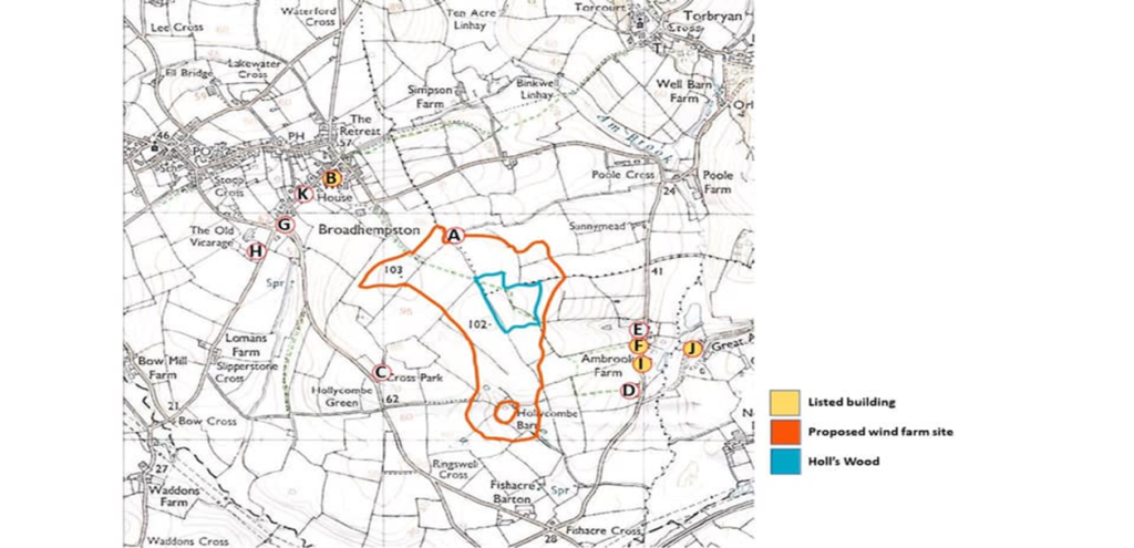
The site lies approximately 450m south of the southern part of the village of Broadhempston, to the south of Wottons Farm and Greyface Farm.

This map shows the site of the planned development and the nearest residential dwellings to the site (range 36.5m to 430metres for Wind site perimeter). See appendix below for more detailed data re distances from residential dwellings.
Mock up illustrations show the potential appearance of the proposed turbines: It appears 4 – 5 120metre high turbines are being proposed (for reference Big Ben is 93 metres high, Salisbury Cathedral is 123 metres high, the London Eye is 135 metres high) on the site. Turbines have to be spaced out to prevent turbulence created by neighbouring turbines compromising their function. Estimates of separation distances required for the size of turbines proposed on this site vary from 4 – 500 metres apart, hence the limitation in numbers.
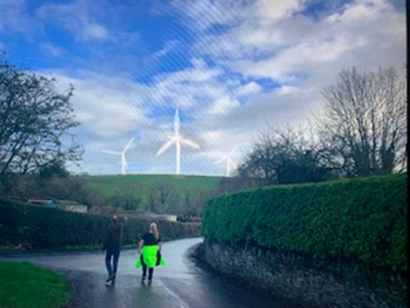
Wind Farm viewed from Houndhead / Vicarage Cross
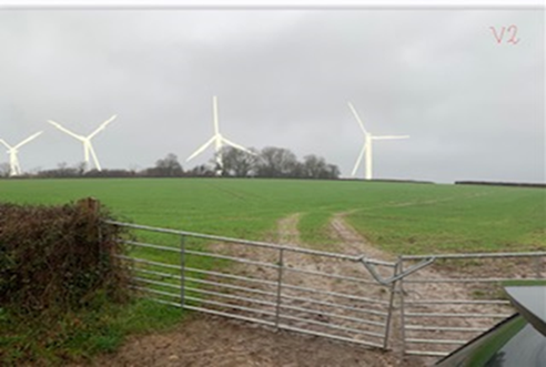
Wind Farm viewed from near Ringwell Cross
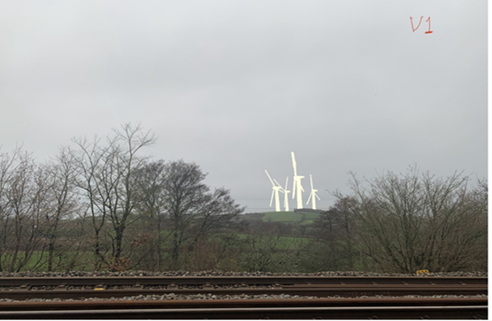
Wind Farm viewed from near Fishacre Bridge
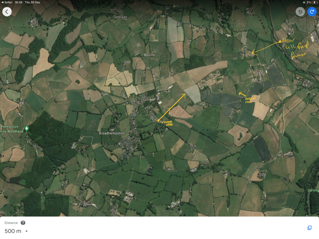
Satellite view to show direction of mock up photos in relation to WS23
The Draft Teignbridge Local Plan review cites the following as being germane to considerations of a proposed Wind Farm on the WS23:
‘avoiding and / or minimising negative impacts on the built and natural environment.’
‘minimum distances from sensitive receptors (such as road, railways and heritage buildings’
‘The parameters found to individually exclude 10% or more of Teignbridge District [from wind Turbine Farm Development] were:
- residential buildings within 400 m (77%),
- wind speed < 6.5 m s -1 @ 80 m elevation (20%),
- B-roads and unclassified roads within 75 m (35%),
- proximity to the Western Power Distribution (WPD) 33 kV grid > 2 km (52%),
- primary surveillance radar (PSR) within line of site at [turbine] tip height of 120 m (40%),
- listed building within 400 m (44%),
- microwave links (23%),
- woodland (18%),
- national park (38%).’
[Analyses} ‘have excluded areas that are likely to impact on a host of natural features, such as woodland and Sites of Special Scientific Interest, sensitive coastal areas, transport & communications constraints, together with heritage assets, including registered parks and gardens and scheduled monuments.’
‘As set out in the National Planning Policy Framework (NPPF), Local Planning Authorities should only grant planning permission for wind development in identified suitable areas as set out in Local Plans.’
We have reached the point where local opinion about this proposal should be voiced. Should this proposal be included in the Local Plan, then planning consent is very likely to be granted and would be very difficult to oppose other than by (very expensive) judicial review.
Discussion
The concerns about the site can be grouped into these areas:
- The negative effect on the landscape in a rural, tranquil area with historic vernacular features
- The negative effect on the residential amenity of the local residents ie their quality of life
- The negative effects on the local ecology and biodiversity (fauna and flora)
- The negative effects on the local Heritage Assets (historic buildings and sites)
- The negative effects on road safety
- The negative effects on television reception
- The negative effects on aviation
- The negative effects of construction work to provide access to the site, the construction of the turbines and their infrastructure
- Promised restoration of the site at the end of the consent period is unlikely
Relevant policies in previously adopted Local Plan
Policy S21 of the Teignbridge Local Plan 2013 – 2033 (adopted 2014)
Identifies Denbury, Broadhempston and Ipplepen as villages. Development of any villages listed in policy 21 will be permitted where it can be demonstrated that it will not have an adverse effect on the integrity of the South Hams SAC.
Policy 22 of the Teignbridge Local Plan 2013 – 2033 (adopted 2014)
Outside of these settlements is identified as countryside under policy S22. As such development needs to be strictly managed to limited uses and takes account of:
The distinctive characteristics and qualities of the Landscape Character Area
The integrity of the green infrastructure and biodiversity networks
The impact on overall travel patterns arising from the scale and type of development proposed
The need to ensure that development in the countryside does not have an adverse effect on the integrity of the South Hams SAC
(https://www.teignbridge.gov.uk/meida/1669/local-plan-2013-33.pdf)
The Draft Local Plan Review part 3 states:
- ‘2.11 All wind turbine development has the potential to affect ecology, the landscape, the historic environment, local amenity and aviation. The site sensitivities, set out for each wind site option, highlight the main constraints affecting each site following a desktop analysis. Some constraints are more significant that others and further investigation into some sites may result in the site being ruled out through the Strategic Environmental Assessment / Sustainability Appraisal or Habitats Regulation assessment.’
‘On these sites (and others where wind turbine development has been demonstrated (sic) to be suitable), development will be permitted where, on balance, the contribution towards renewable energy provision and climate change mitigation outweighs significant harm, which cannot be mitigated, in relation to the following:
- a) the impact of the scheme, together with any cumulative issues, on landscape character, with particular respect to Dartmoor National Park;
- b) biodiversity and geodiversity;
- c) flood risk and water quality;
- d) significance of heritage assets;
- e) agricultural land quality;
- f) residential amenity;
- g) safety;
- h) aviation and telecommunications.’
We will address each of these points where relevant below. (at subsection A1)
- ‘Wind development will be removed once no longer in economic use and the land restored’.
Comment: This is less likely than future requests to repower sites and increase turbine numbers and size. There has been precedent set at other sites where the presence of an established wind site has been used to argue in favour of granting further planning consent for repowering the site with even bigger turbines and clusters at the end of the planning consent periods, rather than dismantling the site and restoring it to its original status. The latter is a considerable undertaking given the massive infrastructure involved (concrete Turbine foundations, on and off site access roads, turbine houses, grid connections ) and also the subsequent need to dispose of components (often the blades are cut up for landfill on or off site. They have a life span of @ 5 years). The implication is once you have a wind Farm you have it for the long term.
- ‘the impact of the scheme, together with any cumulative issues, on landscape character, with particular respect to Dartmoor National Park’
The Teignbridge Local plan Review makes use of the following document and in turn the source documents it refers to:
‘An Assessment of the Landscape Sensitivity to Onshore Wind Energy Developments in Teignbridge District – Final Report Prepared for Teignbridge District Council by LUC March 2017’
This report states:
- ‘Balancing the need to make a meaningful contribution towards reducing harmful emissions from energy use (through cleaner energy production) with the conservation and management of the district’s varied landscapes and seascapes is one of these key challenges. Teignbridge landscape has a significant economic, social and community value, contributing to a sense of identity, well-being, enjoyment and inspiration and being a major contributor to a strong tourism industry. It also has an environmental value, as a home for wildlife and a cultural record of human interaction with the land over millennia.’
- ‘ The Council recognises these opportunities and understands the need to maximise renewable energy generation (which can have environmental, economic, social and other benefits). However, the development of wind energy developments within the landscape needs to be managed carefully to achieve the greatest contribution towards energy needs, while at the same time ensuring that the important characteristics of the landscape are not unacceptably harmed.’
- ‘This study builds on the Devon Landscape Policy Group’s (DLPG) Advice Note No. 2: ‘Accommodating Wind and Solar PV Developments in Devon’s Landscape: Guidance on minimising harm to the distinctive character and special qualities of Devon’s landscape through sensitive siting and design’ , providing a local supplement for Teignbridge District and building on the generic guidance presented in the Advice Note.’
1.8 ‘Generally the landscapes across Teignbridge are relatively small scale, highly rural in character and frequently strongly undulating and intricate. In addition, the landscape features that characterise the area are also relatively small in scale, such as historic buildings, church towers, small-scale medieval fields divided by hedgebanks, windblown trees and woodland. This results in the whole district being assessed as being highly sensitive to the largest scales of wind energy developments – which if introduced are likely to compete with the small scale elements of the landscape that create its existing character. In addition, the landscape’s frequently narrow, sunken lands bordered by Devon hedges are characteristic features which create a practical constraint to the delivery of large scale turbines to a development site, further increasing sensitivity to larger scale wind energy developments.’
‘A thorough desk-based study, drawing on other sources of spatial and descriptive information about the landscape, was supplemented by field survey work by a team of landscape professionals to verify and use professional judgement to produce the landscape sensitivity assessments.’
‘This assessment focuses on the potential landscape issues associated with onshore wind energy developments. It does not provide guidance on the wide range of other planning issues that may need to be considered as part of the preparation and determination of planning applications. These potential issues include:
Ecology and ornithology
Historic environment
Hydrology
Traffic and transport
Noise and vibration
Socio-economic activities (eg. tourism)
Agricultural land use / productivity
It should not however be interpreted as a definitive statement on the suitability of a certain location for a particular development. All developments will need to be assessed on their individual merits.’
Sources which informed this study included:
- Landscape Character Assessment framework
Teignbridge Devon Landscape Character Assessment (2009)
2.6 ‘There are 17 Landscape Character Types falling within Teignbridge District, as identified in the Landscape Character Assessment (2009). Please note that this study has updated some of the coding and LCT names used by the Teignbridge assessment to be consistent with the final classification for the county, as set out in the ‘Devon Menu of Landscape Character Types’ (2012)’:
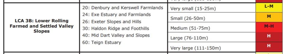
The wind site 23 lies within area 40 ‘Mid Dart valley and Slopes’ and is classified as LCT type 3b ie:Lower Rolling Farmed and valley slopes.
The 2009 Teignbridge Landscape Character Assessment states:
‘2.16 The layout and design should be informed by a Landscape and Visual Impact Assessment. The detail of this assessment will depend upon the scale of the proposed development and whether or not the Environmental Impact Assessment (EIA) Regulations apply.
2.17 It is preferable that heights are in proportion with, and do not overwhelm, the scale of hills, ridges, woodlands and fields. In addition, wind turbines need to respect the hierarchy of elements in the landscape and do not compete, or create clutter when seen together, with other man-made landscape elements such as pylons.
2.18 As there are local variations in landscape character and sensitivity within a Landscape Character Area (LCA), a site-specific analysis should be undertaken to identify specific landscape and visual issues. It is important to consider the potential impact on landscape characteristics, special qualities of landscape designations and potential impact on key views.
2.19 The Assessment of the Landscape Sensitivity to Onshore Wind Energy Developments in the Teignbridge Landscape study (March 2017) contains further guidance on strategic patterns of landscape sensitivity across Teignbridge and how to consider landscape in planning applications for wind energy developments.’
Comment: With regard to points 2.16 – 2.19:
The area highlighted for Wind Farm development on Wind Map Site 23 (south of Broadhempston) is included in the ‘Assessment of the Landscape Sensitivity to Onshore Wind Energy Developments in the Teignbridge Landscape study (March 2017)’.
It lies within the area covered by the Dart Valley and Slopes Landscape Character Area (6.18) as defined by the Teignbridge Landscape Character Assessment 2009, which makes variety of recommendations relating to Settlement and Development including:
‘Conservation of views across the landscape from hilltops
Ensure the sensitive location of new development, avoiding prominent hilltops and slopes
Ensure any development of the network of historic lanes reflects their rural character
Conserve and enhance the strong sense of tranquility through sensitive siting of development with enhancement of hedgerows and woodlands
The landscape pattern of mixed pasture and arable fields with hedgerows, narrow lanes and woodland should be conserved and enhanced and new development should reflect the small scale, historic settlement pattern and vernacular character’
Access to the proposed site is through many narrow, often tortuous, single track roads with passing places, running a considerable distance from adjacent trunk roads. Although Turbine Towers can be delivered in modular form and constructed on site, the 50 + metre Turbine Blades need to be delivered intact. It is difficult to see how this can be achieved by road or rail without considerable and costly road widening/ new road construction. This is not possible without impinging on the Local Character of the area. The lifespan of the blades may be as little as 5 years, so blade traffic would not be confined to initial construction as they would have to be removed and replaced during the putative lifespan of the consent. Cf Den Brook Wind Farm Website (http://www.den-brook-co.uk/about-the-wind-farm/project-summary/) for an example of massive road construction for blade delivery and access and the vehicles involved in delivery of the same.
The development of a Wind Farm with 120 metre turbines on the Hilltop overlooking The Am Brook Valley would appear to be contrary to the recommendations contained in an existing Teignbridge Document suggesting guidance and constraints applicable to any planning application for this area.
The proposed Wind Farm Site also lies within the Landscape Connectivity Zone associated with the South Hams SAC. South Hams DC is aware of this proposal and is preparing a response with respect to cross boundary impacts.
The information included in both the Teignbridge and Devon Landscape Character Assessments provides descriptive information for each of the individual LCTs, forming the primary evidence base for the assessments provided in Appendix 2 in the ‘An Assessment of the Landscape Sensitivity to Onshore Wind Energy Developments in Teignbridge District – Final Report Prepared for Teignbridge District Council by LUC March 2017’
Quoted sources include:
- Devon Landscape Character Assessment (2011)
- Historic Landscape Character Assessment for Devon
Devon’s Historic Landscape Characterisation (HLC), undertaken in 2005, maps historic landscape types found across Devon. The Historic Landscape Types (HLTs) found within Teignbridge, another key source of information used to inform the Landscape Sensitivity Assessment, are mapped at Figure 2.2 [of this document].
‘ For the purposes of this study, it is assumed that landscapes comprising medieval enclosures (including strip fields) have a higher sensitivity to the larger scale wind energy developments than landscapes comprising larger post-medieval or modern enclosures or industrial/military historic landscape types (HLTs). This is due to the potential for the larger scale turbine developments to affect the coherence of these landscapes (including effects of access tracks on field boundaries) and the ability to appreciate them in the landscape. Historic Landscape Types such as rough ground, ancient woodland, other woodland, watermeadows and orchards also have a higher sensitivity to development of wind energy development of any size as a result of potential changes to the coherence of these HLTs.
It will be important that historic landscape character is conserved as far as possible when siting renewable energy development.’
Table 3.1: Development sizes/scales used for this assessment
Height (to blade tip) Cluster size
Very small (15-25m)
Single turbine Small (26-50m) Small (<5 turbines)
Medium sized turbines (51-75m) Medium (6-10 turbines)
Large turbines (76-110m) Large (11-25 turbines)
Very large turbines (111-150m) Very large (>25 turbines)
Table 3.6 Size comparators for wind turbines
Domestic buildings 6-10 metres
Very Small Turbines 15-25m Mature deciduous trees (dependent on species) 10-25m
Small Turbines 26-50m Standard ‘lattice tower’ pylons 46.5m
Medium Turbine 51-75m
Large Turbine 76-110m (Big Ben 93 m)
Very Large Turbine 110-150m (Salisbury Cathedral 123m , London Eye 135m)
Evaluating landscape sensitivity (see below *)
‘There is currently no published method for evaluating the sensitivity of different types of landscape to renewable energy developments. However, the approach taken in this study builds on current guidance published by the Countryside Agency and Scottish Natural Heritage including the Landscape Character Assessment Guidance8 and Topic Paper 69 that accompanies the Guidance, as well as the county-wide approach set out in the DLPG Advice Note 2.’
‘Judging landscape character sensitivity requires professional judgement about the degree to which the landscape in question is robust, in that it is able to accommodate change without adverse impacts on character. This involves making decisions about whether or not significant characteristic elements of the landscape will be liable to loss… and whether important aesthetic aspects of character will be liable to change’
Landscape scale and form
‘Larger scale landforms are likely to be less sensitive than smaller scale landforms – because turbines may appear out of scale, detract from visually important landforms or appear visually confusing (due to turbines being at varying heights) in the latter types of landscapes.’
Comment – Site 23 falls into an area rated as medium to high sensitivity by the report with respect to landscape scale and form
Land cover pattern and presence of human scale features
‘Simple, regular landscapes with extensive areas of consistent ground cover are likely to be less sensitive to wind energy development than landscapes with more complex or irregular land cover patterns, smaller and / or irregular field sizes and landscapes with frequent human scale features that are traditional of the landscape, such as stone farmsteads and small farm woodlands. This is because large features such as wind turbines may dominate smaller scale traditional features within the landscape.’
Comment – Site 23 falls into an area of higher sensitivity with respect to and cover pattern and presence of human scale features (‘Human scale features’ are aspects of land cover such as stone walls, hedges, buildings which give a ‘human scale’ to the landscape).
Tracks / Transport
‘If a Landscape Character Type has a rural road network which contributes to landscape character (eg. winding narrow lanes bounded by high hedgebanks or sunken lanes), this aspect of character may be affected by access works to enable HGVs carrying turbines to a site. This characteristic therefore also influences sensitivity.’
Comment – Site 23 and environs thus fall into an area of higher sensitivity with respect to Tracks / Transport pattern.
Skylines
‘Prominent and distinctive and/or undeveloped skylines, or skylines with important landmark features, are likely to be more sensitive to wind energy development because turbines may detract from these skylines as features in the landscape, or draw attention away from existing landform or landmark features on skylines. These include the skylines of elevated coastlines and coastal headlands. Important landmark features on the skyline might include historic features or monuments.’
Comment – Site 23 and environs thus falls into an area of higher sensitivity with respect to Skylines in that is has a landscape with prominent skylines that may form an important backdrop to views from settlements or important viewpoints, and/or with important landmark features
Perceptual qualities
‘Landscapes that are relatively remote or tranquil (due to freedom from human activity and disturbance and having a perceived naturalness or a strong feel of traditional rurality with few modern human influences) tend to increase levels of sensitivity to wind energy development compared to landscapes that contain signs of modern development (as the development will introduce new and uncharacteristic features which may detract from a sense of tranquillity and or remoteness/ naturalness).’
Comment – Site 23 thus falls into an area of moderate to higher sensitivity with respect to perceptual qualities given the tranquil and rural nature of the environs.
Historic Landscape Character
‘Due to intrinsic historic landscape character significance, or potential for preserved archaeological evidence, historic landscape types (HLTs) such as rough ground with earlier remains, prehistoric fields, watermeadows, and fields with a medieval historic character type such as strip fields, enclosures (strips) and enclosures – medieval have a higher sensitivity to larger scale wind energy development due to their strong historic qualities. Some more recent but discrete enclosed landscapes may also be sensitive, such as ‘barton’ fields. Lower sensitivity landscapes include industrial landscapes, coniferous plantations, airfields, and post medieval/modern enclosures.’
Comment – Site 23 and environs have many of these characteristics and so may be described as moderate to higher sensitivity with respect to Historic landscape character.
Scenic and special qualities
‘Landscapes that have a high scenic quality (which may be recognised as a National Park, Heritage Coast or AONB) will be more sensitive than landscapes of low scenic quality. This is particularly the case where their special qualities (as recorded in the Landscape Character Assessment or designation documents) are likely to be affected by wind energy development. Scenic and special qualities may relate to landscapes that are not designated as well as landscape designated for their natural beauty.’
Comment – Site 23 and environs may be regarded as higher sensitivity with respect to scenic and special qualities in that it is acknowledged that the ‘ landscape has a medium-high scenic quality – most of the special qualities are likely to be affected by wind energy development. Area may be designated locally for its scenic qualities. ‘
Subsection A1 -Observations on landscape sensitivity across Teignbridge
4.2 ‘Generally the landscapes across Teignbridge are relatively small scale (compared to other parts of the country), highly rural in character and frequently strongly undulating and intricate. In addition, the landscape features that characterise the area are also relatively small in scale, such as historic buildings, church towers, small-scale medieval fields divided by hedgebanks, windblown trees and woodland. This results in the whole district being assessed as being highly sensitive to the largest scales of wind energy developments – which if introduced are likely to compete with the small scale elements of the landscape that create its existing character. Therefore the sensitivity of the District’s landscape becomes progressively higher as you move through the different sizes of development (i.e. height categories of turbines. In addition, the landscape’s frequently narrow, sunken lands bordered by Devon hedges are characteristic features which create a practical constraint to the delivery of large scale turbines to a development site, further increasing sensitivity to larger scale wind energy developments.’
4.3 ‘In addition, locations within the LCTs which are adjacent to or intervisible with Dartmoor National Park – therefore forming an important part of its setting – are highly sensitive to wind energy development.’
Table showing sensitivity to turbine height as related to wind site 23
It may be preferable to have fewer larger wind turbines than many small ones to avoid significant cumulative impacts and visual confusion. Guidance provided in the Devon Landscape Policy Group advice note14 should be referred to in relation to assessing the cumulative impacts of multiple schemes. The overall aim should be to make sure that wind energy developments do not become a key characteristic of the landscape of the LCT or have a defining influence on the overall experience of the landscapes of Teignbridge.’
Comment – Analysis of the sensitivities of wind site 23 suggests that a development of a fewer large scale wind turbines, as suggested in the Local Plan proposal part 3, flies in the face of the declared higher sensitivity to such developments on the site within the 2017 Landscape Assessment.
It is noted that the map showing Teignbridge Landscape Sensitivity Assessment of wind energy sensitivity ratings for medium and larger scale wind developments takes note of the criteria contained within the source reference documents quoted above and in particular in relation to the Dart Valley and Slopes (studied in detail in the 2007 document) and thus in relation to wind site 23:
‘Conservation of views across the landscape from hilltops
Ensure the sensitive location of new development, avoiding prominent hilltops and slopes
Ensure any development of the network of historic lanes reflects their rural character
Conserve and enhance the strong sense of tranquility through sensitive siting of development with enhancement of hedgerows and woodlands
The landscape pattern of mixed pasture and arable fields with hedgerows, narrow lanes and woodland should be conserved and enhanced and new development should reflect the small scale, historic settlement pattern and vernacular character’
Access to the proposed site is through many narrow, often tortuous, single track roads running a considerable distance from adjacent trunk roads. Although Turbine Towers can be delivered in modular form and constructed on site, the 50 + metre Turbine Blades need to be delivered intact. It is difficult to see how this can be achieved by road without considerable and costly road widening/ new road construction. This is not possible without impinging on the Local Character of the area. The lifespan of the blades may be as little as 5 years so blade traffic would not be confined to initial construction as they would have to be removed and replaced during the putative lifespan of the consent. Cf Den Brook Wind Farm Website (http://www.den-brook-co.uk/about-the-wind-farm/project-summary/) for an example of massive road construction for blade delivery and access and the vehicles involved in delivery of the same.
The development of a Wind Farm with 120 metre turbines on the hilltop overlooking The Am Brook Valley would appear to be contrary to the recommendations contained in an existing Teignbridge Document suggesting guidance and constraints applicable to any planning application for this area.
Amongst other considerations, the proposed Wind Farm Site 23 also lies within the Landscape Connectivity Zone associated with the South Hams SAC. Cross boundary considerations with respect to intervisibility and other issues are relevant, as they are to the Dartmoor National Park including Haytor.
DCA40 Mid Dart Valley and Slopes / LCA3B Lower Rolling Farmed and Settled Valley Slopes: ‘This character area comprises the valley of the River Dart and tributaries, and surrounding rolling hills and slopes. The Dart flows through a winding, frequently wooded, narrow gorge for much of its course, widening to a flood plain and more expansive river with weirs and more gentle slopes, particularly to the north of the river. Its tributaries including the River Hems (and the Am Brook) lie in narrow valleys, enclosed by rounded hills with limited tree cover; the landscape tends to broaden at confluences. Views are obtained across and along the valleys in places, to nearby hills and the rising mass of Dartmoor to the west. However many views are relatively short and contained, focusing on the rounded hills and rivers which give this area its sense of place. The area is strongly defined by the steep, winding, narrow wooded valley of the Dart and to a lesser extent by its tributaries and surrounding rolling hills. There is a strong sense of tranquillity within the rolling hills and valleys away from settlement and transport infrastructure.’ (Source 2017 Assessment of landscape sensitivities to onshore wind).
Comment – The implication is acceptance that site 23, South of Broadhempston, would be highly sensitive to deleterious effects on the Landscape should medium to large scale turbine developments (as proposed) be permitted thereon.
Biodiversity
‘2.20 Wind energy developments have the potential to impact on ecology and biodiversity. Ecological survey findings should be used to help shape the development proposal to deliver a scheme which results in no net loss to biodiversity, and aims to deliver ecological enhancement. In particular potential impact on birds needs to be assessed, with some species being particularly vulnerable or sensitive to wind developments.’
Comment: The draft report highlights the likelihood of the presence of vulnerable bird species eg Cirl Buntings, Whinchats, Barn Owls Skylarks and Willow Tit in the area. Local sightings confirm this. Careful assessment of the area and assessment of the effects of any mitigation suggested to reduce the risk of bird strikes eg: brightly coloured alternate turbine blades, should also be considered with respect to loss of landscape amenity
‘2.21 Any potential impact on bats also needs to be taken into account. It is therefore important to assess local bat populations and their use of the proposed site for foraging and migrating. The siting of the turbine/s is the key to avoiding impact on bats, for example by distancing the turbine from bat foraging features such as wetland and hedges. Bat surveys therefore play a key role in selecting the most appropriate siting for turbine/s and are considered necessary in most cases.’
Comment: The site surrounds a woodland which will be a key foraging area and roost area for bats. It is known from previous bat observations that Greater and Lesser Horseshoe Bat flyways and maternal roosts encircle the proposed site (Great Ambrook, Poole Farm, Torbryan Church, Well House) with positive identification of the bats flying adjacent to the site confirmed in a recent ecological survey. . Further studies will be needed to assess the extent of these with respect to the site. High flying bat species including the Noctule, Brown Long Eared and Serotine bats are also thought to be present.
According to The Bat Conservation Trust, evidence of bats colliding with wind turbines has been available from the US and Europe since the early 2000s and there is now evidence of this from the UK.
Direct impacts of wind farms can include collision and barotrauma (damage to tissues from air pressure changes around turbines); indirect impacts can include habitat loss (roosts, commuting routes and foraging areas) and fragmentation of bat colonies.
Mitigations used to reduce impact of turbines on bats include turning the turbines off during flight times for vulnerable species. This is likely to have economic implications for sites generation /output .
South Hams SAC
The proposed site lies within the landscape connectivity zone of the South Hams Special Area for Conservation and as such any development that causes loss, damage or disturbance requires a Habitat Regulations Assessment to be submitteda as part of a planning application.
‘Greater Horseshoe Bats are one of britain’s rarest bats and are confined to the South West Of England and South Wales. Over 2,500 Greater Horseshoe Bats are found in South Devon (a significant proportion of the British Population) and the Buckfastleigh maternity roost is thought to be the largest in Europe’ Devon County Council, South Hams SAC 2019’
(Devon Greater Horseshoe Bat Project – https://www.devonwildlifetrust.org/what-we-do-our-projects/devon-greater-horseshoe-bat-project)
Torbryan Church and Great Ambrook House are identified as maternal roosts for the Greater Horseshoe Bat and the bats have been identified as flying in the grounds of Well House adjacent to WS23 in a recent ecological survey undertaken as part of a planning application for re roofing. As a result the reroofing was require to provide access for bats in anticipation of future breeding.
More extensive information is available in the following:
Conservation of Habitats and Species Regulations 2017 Schedule 2
https://www.bats.org.uk/threats-to-bats/wind-farms-and-wind-turbines
Devon Greater Horseshoe Bat Project – https://www.devonwildlifetrust.org/what-we-do-our-projects/devon-greater-horseshoe-bat-project
Great Crested Newts
‘Great Crested Newt presence likely due to ponds.’
Comment: The Draft Local Plan Review mentions that the presence of Greater Crested Newts (also a protected species under Schedule 2 of the 2017 act) is a barrier to permitted development of the site. Great Crested Newts have been identified in ponds and gardens in close proximity to the site in the last year and are therefore likely to be present in the ponds embraced by the site.
List of Devon Special Species Review 2020
( https://devoncc.sharepoint.com/:w:/s/PublicDocs/Environment/ EXd65V8Tj0tOrH8jX9Pgw-YBO9QbtknQZ-DkCjjPF2xceQ?e=Y20fYR )
Orley Common – County Wildlife Site
‘Orley Common is a fragile site of great value for its wildlife, geology and historical interest.
Because it has fairly undisturbed ancient grassland and ancient woodland, it is very species-
rich, with County and national rarities(including the Brown Hairstreak Butterfly). It is particularly important to local people for quiet recreation. and there are some excellent views from the highest point.’
The primary views from Orley Common are across the Am Brook Valley to the hilltop where Site 23 lies. The landscape and local amenity of Orley Common will be impaired by development of the wind farm at WS23
(https://www.teignbridge.gov.uk/sports-and-leisure/parks-and-open-areas/other-habitats/orley- common/)
Torbryan Caves – Designation : Site of Special Scientific Interest – Scheduled Ancient Monument (Historical England list entry 1002555 – The Old Grotto, Dyer’s Wood), Geological Conservation review,
19.11 Ha of ‘favourable’ land identified by Natural England to the East of the proposed site.
“This site comprises a series of caves, in a ridge of Devonian Limestone, that are of importance to the study and dating of Pleistocene fossil fauna. Several of the caves are also bat roosts. The caves (including the famous ‘Tornewton Cave’) represent one of the most important Pleistocene localities in Britain and provide a clear sequence of the fossil fauna representing the Wolstonian Cold Stage/Ipswichian Interglacial/Devensian Cold Stage Cycle. Equally significant is the occurrence of the remains of species long extinct in Britain and seldom found as fossils in this country. Fossil evidence of the clawless otter Aonyx antigua and steppe lemming Lagurus lagurus is unique to this site, while fossil remains of glutton Gulo gulo and hamsters Cricetus cricetus and Allocricetus bursae are only rarely found elsewhere. The last named species is extinct. Many of the faunistically older deposits (The Glutton and Bear Strata) remain in situ within the cave deposits. The Devensian horizons, including the Reindeer Stratum which are the youngest deposits, occur extensively in sediments at the front of the cave entrances. The caves are also used by several species of bat: greater horseshoe Rhinolophus ferrumequinum, lesser horseshoe R. hipposideros and long-eared Plecotus spp. bats have been recorded at this site.”
(https://designatedsites.naturalengland.org.uk/PDFsForWeb/Citation/1003087.pdf )
Heritage
2.23’ Wind energy developments generally have the potential to affect heritage assets (archaeological sites, monuments, buildings and landscape features) both above and below ground.’
2.24 ‘Above ground impacts may include the effects on the setting of Listed Buildings and Scheduled Monuments as well as on the Historic Landscape Character of Teignbridge. Section 66 of the Planning (Listed Buildings and Conservation Areas) Act 1990 places a statutory duty on local planning authorities to have “special regard to the desirability of preserving” listed buildings and their settings. This means that the setting of designated heritage assets must be appropriately assessed and considerable importance and weight will be given to the desirability of preserving the setting of listed buildings when the applications are determined.’
2.25 ‘Where wind energy proposals lie within a visual envelope of designated heritage assets, planning applications should be supported by an assessment of the setting of historic assets using the latest English Heritage guidance.’
2.27 ‘Development will also need to accord with the provisions of the Local Plan policies EN16 – Heritage Assets and EN17 – Conservation Areas’
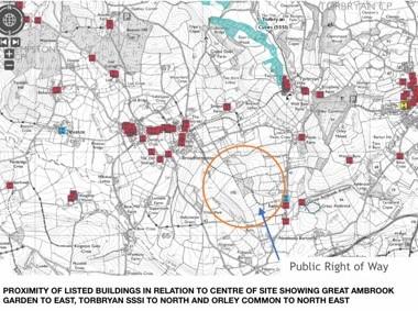
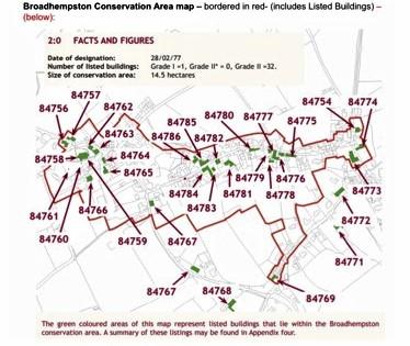
The proposed site WS23 lies in close proximity to 2 scheduled ancient monuments, 3 grade 1 listed buildings, a grade 11* listed building and over 100 grade 11 listed buildings and structures in the Broadhempston and Denbury Conservation Areas.
Comment – With regard to points 2.23 – 2.27: The site is encircled by heritage assets in the form of Listed Buildings and Structures, as well as Conservation Areas eg. Broadhempston and Denbury. The impact of new developments, such as wind farms, is strictly regulated with respect to their impact on heritage buildings and their environs.
A large part of the attraction of Devon for tourists lies in the historic architecture and its complimentary landscape. Adverse landscape effects of wind farm development will impact on local amenity, discourage tourism and damage the local economy associated with tourism
.
The proposed site WS23 lies in close proximity (nearest 300 – 400 metres) to 2 scheduled ancient monuments (Denbury Down Iron Age Settlement and The Grotto, Dyer’s Wood), 1 registered garden (The Italian Garden at Great Ambrook), 3 grade 1 listed buildings, a grade 2* listed building and over 100 grade 2 listed buildings and structures, as well as the Broadhempston and Denbury Conservation Areas.
27 27 s the high degree of impact that a wind turbine development would cause to these heritage assets)
(Teignbridge District Council Landscape Character Assessment Study 2009 Proximity of Heritage features map.
Teignbridge District Conservation Area Appraisal – Broadhempston
https://www.teignbridge.gov.uk/media/4387/broadhempston_ conservation_appraisal_ web_2012.pdf
Teignbridge District Council Conservation Area Appraisal – Denbury
https://www.teignbridge.gov.uk/media/4395/denbury_ appraisal_web 2012.pdf)
Broadhempston – 56 listings (https://historicengland.org.uk/listing/the-list/results/?searchType=NHLE+simple&search=broadhempston&page=3)
The following is a list of the distances measured with a laser rangefinder from these properties to the nearest edge of the proposed site. Note that the prevailing southwesterly winds will mean properties lying to the north east of the site will be more likely to suffer from noise pollution as a result of gearbox noise and turbine blade swish.
A – Broad Park to nearest edge of WS 23 – 36.5 metres
B – Well House (Grade 11) to nearest edge of WS 23 – 320 metres
C – Cross Park to nearest edge of WS 23 – 329 metres
D – The Burrow to nearest edge of WS 23 – 371 metres
E – Little Ambrook to nearest edge of WS 23 – 388 metres
F – Ambrook Farm House (Grade 11*) to nearest edge of WS 23- 391 metres
G – Houndhead Cross to SW extreme of WS 23 – 400 metres
H – Old Police House to SW extreme of WS 23 – 448 metres
I – High Barn (Grade11) to nearest boundary WS 23 – 426 metres
J – Great Ambrook House (Grade 11) and curtilage to nearest boundary WS 23 – 430 metres
Other listed buildings include:
- Poole Farmhouse (Grade11)
- Simpson’s Farm (Grade 11)
- Holy Trinity Church, Torbryan (Grade1)
- Particularly notable Heritage Assets which will be affected by WS23 development include the following
- Church of St Peter and St Paul (Grade 1 listed)
- The grade 2 Italian Garden at Great Ambrook overlooks the proposed wind farm site. It was cited by the Heritage Lottery Fund as ‘Devon’s answer to the Lost Gardens of Heligan’ and is a recent recipient of a £48,900 grant from the National Lottery Heritage Fund to fund ‘essential conservation work and to launch a programme of community engagement’, an intitiative which has the full support of Teignbridge District Council. The principle designed view from the garden is from the Observatory to Haytor Rocks, on Dartmoor. Establishment of a wind farm on the hill top overlooking the Italian Garden would have a considerable effect on the landscape amenity as it would like within the sector which embraces this historic designed view. The importance of preservation of the setting and the vistas from the Italian Garden are highlighted by the recent refusal of planning by Teignbridge for development adjacent to the garden.
Planning documents -17/01462/FUL and 19/01586/FUL)
(https://theitaliangarden.org/Story-Ethos)
Historic England Listing No.14119629
Residential Amenity
‘2.30 The relationship of renewable energy developments to residential amenity will need to be addressed where nearby properties exist. The impact on the amenity of residential dwellings must be considered.
2.31 Development will need to accord with the provisions of Local Plan Policy H11: Residential Amenity with particular emphasis on identified impacts of dominance, flicker and overshadowing/loss of light.’
Comment: with reference to 2.30-2.31
The effects of the proposed turbines with respect to dominance, flicker especially with the low angle of incident sunlight at the extremes of the day) and overshadowing/loss of light will need to be considered in the light of the size and position of the Turbines proposed. For scale 120 metre turbines would be considerably higher than ‘Big Ben’ (93 metres) and their elevated position overlooking the village and surrounding residences must increase the risk of loss of residential amenity from these.
‘2.32 Noise implications from movement of the blades through the air and mechanical noise from the generator and any associated gearbox require consideration. A noise report undertaken by a qualified acoustician is required as part of any wind turbine planning application. This will enable an assessment of the noise produced by the turbine, both on its own and cumulatively with any other turbines in the area, and whether it will have an adverse effect on the amenity of nearby noise sensitive premises (e.g. homes, schools).’
Comment: A factor which causes concern about living in proximity to a wind farm is the level of noise generated by the turbines. Turbines of the size proposed function 24 hours a day, in wind ranges from Beaufort force 2 – 10, unless shut down for maintenance or other reasons.
Noise pollution is produced through ‘Gearbox Noise’ and ’Blade Swish’ and this increases with wind force, as does the ambient environmental noise (the sound of the wind in the trees). The ambient noise levels in a rural environment, such as this, are usually estimated to be around 35 decibels (ETSU) at night. Local measurements show ambient noise in the region of 32 – 32 decibels laEq. Turbines such as those proposed produce 45 – 50 decibels at relatively low wind speeds.
Government reports state that where ambient noise outside a residential dwelling is exceeded by 10 decibels during quiet night time hours, sleep disturbance is likely to be experienced. Distance from the turbines obviously reduces the perceived noise and multiple turbines increase it. Wind direction makes a huge difference to sound propagation, with those living downwind of the turbines experiencing higher perceived noise levels.
There are laws in Wales, Scotland, Northern Ireland, Ireland and other EU countries which set a limit on the minimum distance it is permissible to build turbines from a residential dwelling. Most of these state distances of at least 500 m and some up to 1000m as lower limits. The nearest residential dwelling to the proposed site is actually under 50 m (fifty) from the margin of the site and lies downwind in the prevailing winds from the South West. Houses to the South lie within 330 m; houses to the East and North East lie within 400m and houses to the West, from the Houndhead Cross area past Well House to No Place Hill, all lie within 400m metres. In other words well below most internationally acceptable limits.
It is highly likely therefore that a wind farm at the proposed site will cause considerable noise nuisance to the residents who live around the siteTLocal residents are already sensitized to the effects of noise pollution, especially those who live to the North West of the Motocross Course and thus the north West margin of the proposed site, where the directionality of the prevailing winds funnels noise, which in turn tends to echo around the amphitheatre of the upper Am Brook Valley. Whilst the noise of the Moto Cross is intrusive it has the merit of being very infrequent, unlike the 24/7 potential noise pollution from a wind farm.
With reference to:
‘The Assessment and Rating of Noise from Wind Farms ETSU – R – 97’ … a report prepared for the DTI by the Working Group on Noise from Wind Turbines.
According to the ETSU report, the average ambient background noise levels for this rural area is likely to be in the region of 35dBLAeq, findings backed up by local residents’ noise level readings (see below). The report states that sleep disturbance is likely due to Turbine Gearbox noise and Blade Swish where it exceeds background noise levels outside a residential dwelling by 10 dBLAeq. Given the proximity of the residential dwellings to the proposed site this is highly likely to be the case with this development, as the noise rating estimates for 2Mw turbines seem to lie between at least 45 – 50 dB.
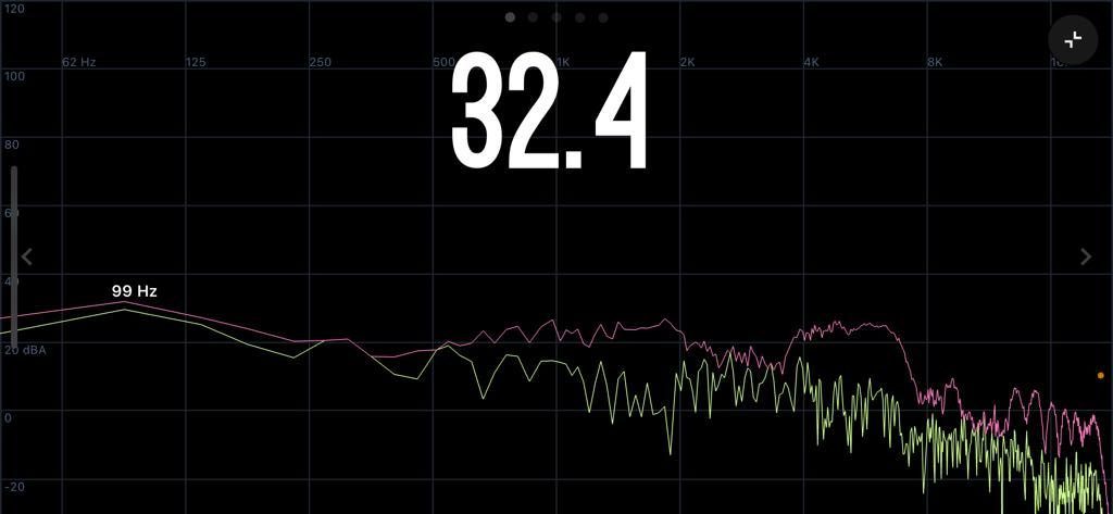
Ambient sound level reading (dB) on Wind Site 23 at 0700 on 09/1/22
Safety
The Teignbridge Local Plan review 2020 – 2040 states that:
‘2.35 When in close proximity to highways, turbines should wherever possible be located away from junctions, tight bends and crossings.’
Comment: The site is surrounded by single track roads with passing places which carry regular traffic to and from Broadhempston and surrounding hamlets and in particular in adjacent to several sharp bends eg Lower Well and offset junctions eg Houndhead Cross. These roads have some of the highest figures for road traffic incidents per mile for any road. Large turbines on the adjacent hill tops within 400 metres will be quite a distraction for motorists and could compromise road safety.
Aviation
The Am Brook Valley and Slopes is frequently used for low level flying exercises by MOD aircraft. A wind Farm development would represent a significant hazard to such activity
Telecommunications
‘2.37 Wherever possible the siting of wind turbines should avoid radio and microwave signal corridors and impacts upon domestic TV and radio reception. If this is not possible, mitigation measures may be required.’
Comment: The proposed site lies in direct line between the Beacon Hill Microwave TV Tower and Broadhempston Village and it is likely that residents will experience interference with digital TV and radio signal. Turbines will cause scattering and multipathing of signals, causing distortion and fading of reception. This is undesirable given that some already experience poor TV and radio signals.
SUMMARY
The comments recorded in this document demonstrate that there are multiple reasons for the non adoption of the proposed wind farm development at Wind Site 23 and the signatories contend that for these reasons this proposal should not be included in the Teignbridge Local Plan 2020 -2040
The domains where significant concerns with regard to the impact of such a development have been demonstrated are:
- a) the impact of the scheme, together with any cumulative issues, on landscape character, with particular respect to Dartmoor National Park and the South Hams SAC
- b) The negative effects on biodiversity
- c) The impact on local heritage assets
- d) agricultural land loss
- e) The negative effects on residential amenity
- f) The negative effects on safety
- g) The negative effects on aviation
- h) The negative effects on telecommunications
- j) The negative effects of construction work to provide access to the site, the construction of the turbines and their subsequent maintenance
- k) Promised restoration of the site at the end of the end of the planned consent period.
